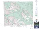
Maps showing Condor Peak, Alberta
Condor Peak is a Mountain located in Alberta and has an elevation of 2679 meters.
- Latitude: 51° 47' 38'' North (decimal: 51.7938888)
- Longitude: 115° 55' 18'' West (decimal: -115.9216666)
- Topography Feature Category: Mountain
- Geographical Feature: Peak
- Canadian Province/Territory: Alberta
- Elevation: 2679 meters
- Atlas of Canada Locator Map: Condor Peak
- GPS Coordinate Locator Map: Condor Peak Lat/Long
Condor Peak NTS Map Sheets