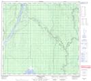
Maps showing McClelland Creek, 1-99-8-W4, Alberta
McClelland Creek is a River located in 1-99-8-W4, Alberta.
- Latitude: 57° 33' 58'' North (decimal: 57.5661111)
- Longitude: 111° 9' 54'' West (decimal: -111.1649999)
- Topography Feature Category: River
- Geographical Feature: Creek
- Canadian Province/Territory: Alberta
- Location: 1-99-8-W4
- Atlas of Canada Locator Map: McClelland Creek
- GPS Coordinate Locator Map: McClelland Creek Lat/Long
McClelland Creek NTS Map Sheets