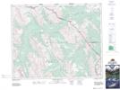
Maps showing Snow Creek Summit, Alberta
Snow Creek Summit is a Valley located in Alberta and has an elevation of 2305 meters.
- Latitude: 51° 36' 31'' North (decimal: 51.6086111)
- Longitude: 115° 48' 38'' West (decimal: -115.8105555)
- Topography Feature Category: Valley
- Geographical Feature: Pass
- Canadian Province/Territory: Alberta
- Elevation: 2305 meters
- Atlas of Canada Locator Map: Snow Creek Summit
- GPS Coordinate Locator Map: Snow Creek Summit Lat/Long
Snow Creek Summit NTS Map Sheets