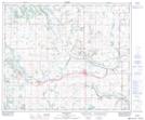
Maps showing Bauer's Lake, 1-50-8-W4, Alberta
Bauer's Lake is a Lake located in 1-50-8-W4, Alberta.
- Latitude: 53° 17' 4'' North (decimal: 53.2844444)
- Longitude: 111° 2' 58'' West (decimal: -111.0494443)
- Topography Feature Category: Lake
- Geographical Feature: Lake
- Canadian Province/Territory: Alberta
- Location: 1-50-8-W4
- Atlas of Canada Locator Map: Bauer's Lake
- GPS Coordinate Locator Map: Bauer's Lake Lat/Long
Bauer's Lake NTS Map Sheets