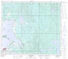
Maps showing Cache Lake, 3,4,33,34-68,69-13-4W, Alberta
Cache Lake is a Lake located in 3,4,33,34-68,69-13-4W, Alberta.
- Latitude: 54° 55' 50'' North (decimal: 54.9305999)
- Longitude: 111° 54' 50'' West (decimal: -111.9139000)
- Topography Feature Category: Lake
- Geographical Feature: Lake
- Canadian Province/Territory: Alberta
- Location: 3,4,33,34-68,69-13-4W
- Atlas of Canada Locator Map: Cache Lake
- GPS Coordinate Locator Map: Cache Lake Lat/Long
Cache Lake NTS Map Sheets