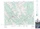
Maps showing Ehagay Nakoda, 24-10,11-W5, Alberta
Ehagay Nakoda is a Mountain located in 24-10,11-W5, Alberta.
- Latitude: 51° 3' 11'' North (decimal: 51.0530555)
- Longitude: 115° 23' 31'' West (decimal: -115.3919443)
- Topography Feature Category: Mountain
- Geographical Feature: Mountain
- Canadian Province/Territory: Alberta
- Location: 24-10,11-W5
- Atlas of Canada Locator Map: Ehagay Nakoda
- GPS Coordinate Locator Map: Ehagay Nakoda Lat/Long