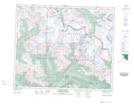
Maps showing Snowbird Pass, 48-8-W6, Alberta
Snowbird Pass is a Valley located in 48-8-W6, Alberta.
- Latitude: 53° 8' 44'' North (decimal: 53.1455555)
- Longitude: 119° 2' 58'' West (decimal: -119.0494444)
- Topography Feature Category: Valley
- Geographical Feature: Pass
- Canadian Province/Territory: Alberta
- Location: 48-8-W6
- Atlas of Canada Locator Map: Snowbird Pass
- GPS Coordinate Locator Map: Snowbird Pass Lat/Long
Snowbird Pass NTS Map Sheets