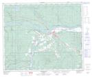
Maps showing Alexis Whitecourt 232, 60,61-12,13-W5, Alberta
Alexis Whitecourt 232 is a Indian Reserve located in 60,61-12,13-W5, Alberta.
- Latitude: 54° 13' 30'' North (decimal: 54.2250000)
- Longitude: 115° 49' 1'' West (decimal: -115.8169000)
- Topography Feature Category: Indian Reserve
- Geographical Feature: Indian Reserve - Réserve indienne
- Canadian Province/Territory: Alberta
- Location: 60,61-12,13-W5
- Atlas of Canada Locator Map: Alexis Whitecourt 232
- GPS Coordinate Locator Map: Alexis Whitecourt 232 Lat/Long
Alexis Whitecourt 232 NTS Map Sheets