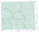
Maps showing O'Chiese 203, 14-44-10-W5, Alberta
O'Chiese 203 is a Indian Reserve located in 14-44-10-W5, Alberta.
- Latitude: 52° 47' 48'' North (decimal: 52.7966666)
- Longitude: 115° 19' 35'' West (decimal: -115.3263889)
- Topography Feature Category: Indian Reserve
- Geographical Feature: Indian Reserve - Réserve indienne
- Canadian Province/Territory: Alberta
- Location: 14-44-10-W5
- Atlas of Canada Locator Map: O'Chiese 203
- GPS Coordinate Locator Map: O'Chiese 203 Lat/Long
O'Chiese 203 NTS Map Sheets