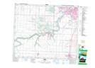
Maps showing Stony Plain 135, 10-52-26-W4, Alberta
Stony Plain 135 is a Indian Reserve located in 10-52-26-W4, Alberta.
- Latitude: 53° 28' 59'' North (decimal: 53.4830556)
- Longitude: 113° 45' 6'' West (decimal: -113.7516667)
- Topography Feature Category: Indian Reserve
- Geographical Feature: Indian Reserve - Réserve indienne
- Canadian Province/Territory: Alberta
- Location: 10-52-26-W4
- Atlas of Canada Locator Map: Stony Plain 135
- GPS Coordinate Locator Map: Stony Plain 135 Lat/Long