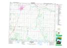
Maps showing Samson 137A, 4-44-24-W4, Alberta
Samson 137A is a Indian Reserve located in 4-44-24-W4, Alberta.
- Latitude: 52° 45' 24'' North (decimal: 52.7566666)
- Longitude: 113° 26' 00'' West (decimal: -113.4333332)
- Topography Feature Category: Indian Reserve
- Geographical Feature: Indian Reserve - Réserve indienne
- Canadian Province/Territory: Alberta
- Location: 4-44-24-W4
- Atlas of Canada Locator Map: Samson 137A
- GPS Coordinate Locator Map: Samson 137A Lat/Long
Samson 137A NTS Map Sheets