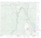
Maps showing Fort McKay 174, 94-11-W4, Alberta
Fort McKay 174 is a Indian Reserve located in 94-11-W4, Alberta.
- Latitude: 57° 9' 43'' North (decimal: 57.1619443)
- Longitude: 111° 37' 16'' West (decimal: -111.6211110)
- Topography Feature Category: Indian Reserve
- Geographical Feature: Indian Reserve - Réserve indienne
- Canadian Province/Territory: Alberta
- Location: 94-11-W4
- Atlas of Canada Locator Map: Fort McKay 174
- GPS Coordinate Locator Map: Fort McKay 174 Lat/Long
Fort McKay 174 NTS Map Sheets