Maps showing Devil's Gate 220, 11-113-8-W4, Alberta
Devil's Gate 220 is a Indian Reserve located in 11-113-8-W4, Alberta.
- Latitude: 58° 48' 30'' North (decimal: 58.8083333)
- Longitude: 111° 13' 0'' West (decimal: -111.2166667)
- Topography Feature Category: Indian Reserve
- Geographical Feature: Indian Reserve - Réserve indienne
- Canadian Province/Territory: Alberta
- Location: 11-113-8-W4
- Atlas of Canada Locator Map: Devil's Gate 220
- GPS Coordinate Locator Map: Devil's Gate 220 Lat/Long
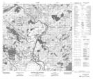
Devil's Gate 220 NTS Map Sheets