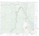
Maps showing Fort Mckay 174D, Alberta
Fort Mckay 174D is a Indian Reserve located in Alberta.
- Latitude: 57° 12' 18'' North (decimal: 57.2049999)
- Longitude: 111° 39' 2'' West (decimal: -111.6505555)
- Topography Feature Category: Indian Reserve
- Geographical Feature: Indian Reserve - Réserve indienne
- Canadian Province/Territory: Alberta
- Atlas of Canada Locator Map: Fort Mckay 174D
- GPS Coordinate Locator Map: Fort Mckay 174D Lat/Long
Fort Mckay 174D NTS Map Sheets