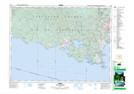
Maps showing Buck Hill, Goldstream Land District, British Columbia
Buck Hill is a Mountain located in Goldstream Land District, British Columbia and has an elevation of 282 meters.
- Latitude: 48° 24' 37'' North (decimal: 48.4102777)
- Longitude: 123° 37' 43'' West (decimal: -123.6286111)
- Topography Feature Category: Mountain
- Geographical Feature: Hill
- Canadian Province/Territory: British Columbia
- Elevation: 282 meters
- Location: Goldstream Land District
- Atlas of Canada Locator Map: Buck Hill
- GPS Coordinate Locator Map: Buck Hill Lat/Long