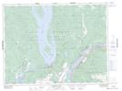
Maps showing Echo Island, Yale Division Yale Land District, British Columbia
Echo Island is a Island located in Yale Division Yale Land District, British Columbia and has an elevation of 209 meters.
- Latitude: 49° 21' 26'' North (decimal: 49.3572222)
- Longitude: 121° 47' 32'' West (decimal: -121.792222)
- Topography Feature Category: Island
- Geographical Feature: Island
- Canadian Province/Territory: British Columbia
- Elevation: 209 meters
- Location: Yale Division Yale Land District
- Atlas of Canada Locator Map: Echo Island
- GPS Coordinate Locator Map: Echo Island Lat/Long