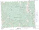
Maps showing Coal Creek, Kootenay Land District, British Columbia
Coal Creek is a Unincorporated area located in Kootenay Land District, British Columbia.
- Latitude: 49° 29' 10'' North (decimal: 49.4860999)
- Longitude: 114° 59' 00'' West (decimal: -114.9833000)
- Topography Feature Category: Unincorporated area
- Geographical Feature: Former Locality
- Canadian Province/Territory: British Columbia
- Location: Kootenay Land District
- GPS Coordinate Locator Map: Coal Creek Lat/Long
Coal Creek NTS Map Sheets