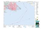
Maps showing Smith Hill, Victoria Land District, British Columbia
Smith Hill is a Mountain located in Victoria Land District, British Columbia and has an elevation of 42 meters.
- Latitude: 48° 26' 43'' North (decimal: 48.4452777)
- Longitude: 123° 21' 12'' West (decimal: -123.3533333)
- Topography Feature Category: Mountain
- Geographical Feature: Hill
- Canadian Province/Territory: British Columbia
- Elevation: 42 meters
- Location: Victoria Land District
- Atlas of Canada Locator Map: Smith Hill
- GPS Coordinate Locator Map: Smith Hill Lat/Long