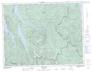
Maps showing Karmutzen Range, Rupert Land District, British Columbia
Karmutzen Range is a Mountain located in Rupert Land District, British Columbia and has an elevation of 991 meters.
- Latitude: 50° 22' 48'' North (decimal: 50.38)
- Longitude: 127° 0' 46'' West (decimal: -127.012778)
- Topography Feature Category: Mountain
- Geographical Feature: Range
- Canadian Province/Territory: British Columbia
- Elevation: 991 meters
- Location: Rupert Land District
- Atlas of Canada Locator Map: Karmutzen Range
- GPS Coordinate Locator Map: Karmutzen Range Lat/Long
Karmutzen Range NTS Map Sheets