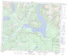
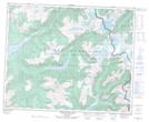
Maps showing North Arm, Kamloops Division Yale Land District, British Columbia
North Arm is a Bay located in Kamloops Division Yale Land District, British Columbia.
- Latitude: 52° 12' North (decimal: 52.1999999)
- Longitude: 119° 41' West (decimal: -119.6832999)
- Topography Feature Category: Bay
- Geographical Feature: Arm
- Canadian Province/Territory: British Columbia
- Location: Kamloops Division Yale Land District
- Atlas of Canada Locator Map: North Arm
- GPS Coordinate Locator Map: North Arm Lat/Long
North Arm NTS Map Sheets