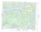
Maps showing Duncan Bay, Range 1 Coast Land District, British Columbia
Duncan Bay is a Bay located in Range 1 Coast Land District, British Columbia.
- Latitude: 50° 41' 31'' North (decimal: 50.6919444)
- Longitude: 125° 42' 5'' West (decimal: -125.701389)
- Topography Feature Category: Bay
- Geographical Feature: Bay
- Canadian Province/Territory: British Columbia
- Location: Range 1 Coast Land District
- GPS Coordinate Locator Map: Duncan Bay Lat/Long
Duncan Bay NTS Map Sheets