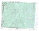
Maps showing Kay Creek, Sayward Land District, British Columbia
Kay Creek is a River located in Sayward Land District, British Columbia.
- Latitude: 50° 11' 48'' North (decimal: 50.1967000)
- Longitude: 125° 44' 30'' West (decimal: -125.7417000)
- Topography Feature Category: River
- Geographical Feature: Creek
- Canadian Province/Territory: British Columbia
- Location: Sayward Land District
- Atlas of Canada Locator Map: Kay Creek
- GPS Coordinate Locator Map: Kay Creek Lat/Long
Kay Creek NTS Map Sheets