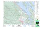
Maps showing Princess Cove, Cowichan Land District, British Columbia
Princess Cove is a Bay located in Cowichan Land District, British Columbia and has an elevation of 5 meters.
- Latitude: 48° 56' 32'' North (decimal: 48.9421999)
- Longitude: 123° 33' 5'' West (decimal: -123.5514000)
- Topography Feature Category: Bay
- Geographical Feature: Cove
- Canadian Province/Territory: British Columbia
- Elevation: 5 meters
- Location: Cowichan Land District
- Atlas of Canada Locator Map: Princess Cove
- GPS Coordinate Locator Map: Princess Cove Lat/Long