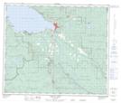
Maps showing Williams Prairie Meadow Indian Reserve 1A, Range 5 Coast Land District, British Columbia
Williams Prairie Meadow Indian Reserve 1A is a Indian Reserve located in Range 5 Coast Land District, British Columbia.
- Latitude: 54° 28' 20'' North (decimal: 54.4722219)
- Longitude: 124° 11' 40'' West (decimal: -124.1944398)
- Topography Feature Category: Indian Reserve
- Geographical Feature: Indian Reserve
- Canadian Province/Territory: British Columbia
- Location: Range 5 Coast Land District
- Atlas of Canada Locator Map: Williams Prairie Meadow Indian Reserve 1A
- GPS Coordinate Locator Map: Williams Prairie Meadow Indian Reserve 1A Lat/Long
Williams Prairie Meadow Indian Reserve 1A NTS Map Sheets