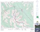
Maps showing Watch Tower Creek, Kootenay Land District, British Columbia
Watch Tower Creek is a River located in Kootenay Land District, British Columbia.
- Latitude: 51° 24' 10'' North (decimal: 51.4028000)
- Longitude: 116° 20' 40'' West (decimal: -116.3443999)
- Topography Feature Category: River
- Geographical Feature: Creek
- Canadian Province/Territory: British Columbia
- Location: Kootenay Land District
- Atlas of Canada Locator Map: Watch Tower Creek
- GPS Coordinate Locator Map: Watch Tower Creek Lat/Long