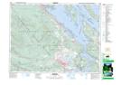
Maps showing Sollys Lake, Somenos Land District, British Columbia
Sollys Lake is a Lake located in Somenos Land District, British Columbia.
- Latitude: 48° 50' 55'' North (decimal: 48.8485999)
- Longitude: 123° 42' 5'' West (decimal: -123.7013999)
- Topography Feature Category: Lake
- Geographical Feature: Lake
- Canadian Province/Territory: British Columbia
- Location: Somenos Land District
- Atlas of Canada Locator Map: Sollys Lake
- GPS Coordinate Locator Map: Sollys Lake Lat/Long