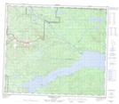
Maps showing Réserve indienne Bihl' K' A 18, Cassiar Land District, British Columbia
Réserve indienne Bihl' K' A 18 is a Indian Reserve located in Cassiar Land District, British Columbia.
- Latitude: 55° 0' North (decimal: 55.0019443)
- Longitude: 125° 23' West (decimal: -125.3836111)
- Topography Feature Category: Indian Reserve
- Geographical Feature: Réserve indienne
- Canadian Province/Territory: British Columbia
- Location: Cassiar Land District
- Atlas of Canada Locator Map: Réserve indienne Bihl' K' A 18
- GPS Coordinate Locator Map: Réserve indienne Bihl' K' A 18 Lat/Long
Réserve indienne Bihl' K' A 18 NTS Map Sheets