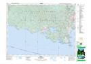
Maps showing Champ de tir Île de Bentinck, Metchosin Land District, British Columbia
Champ de tir Île de Bentinck is a Military area located in Metchosin Land District, British Columbia and has an elevation of 1 meters.
- Latitude: 48° 18' 46'' North (decimal: 48.3127999)
- Longitude: 123° 32' 30'' West (decimal: -123.5417000)
- Topography Feature Category: Military area
- Geographical Feature: C.M.F.C.
- Canadian Province/Territory: British Columbia
- Elevation: 1 meters
- Location: Metchosin Land District
- Atlas of Canada Locator Map: Champ de tir Île de Bentinck
- GPS Coordinate Locator Map: Champ de tir Île de Bentinck Lat/Long