Maps showing Anthony Island (South Moresby) World Heritage Site, British Columbia
Anthony Island (South Moresby) World Heritage Site is a Conservation area located in British Columbia.
- Latitude: 52° 5' 50'' North (decimal: 52.0972000)
- Longitude: 131° 13' 0'' West (decimal: -131.2166999)
- Topography Feature Category: Conservation area
- Geographical Feature: World Heritage Site
- Canadian Province/Territory: British Columbia
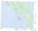
- Atlas of Canada Locator Map: Anthony Island (South Moresby) World Heritage Site
- GPS Coordinate Locator Map: Anthony Island (South Moresby) World Heritage Site Lat/Long
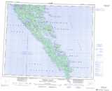
Anthony Island (South Moresby) World Heritage Site NTS Map Sheets