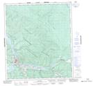
Maps showing Moosehide Creek 2, Yukon
Moosehide Creek 2 is a Indian Reserve located in Yukon.
- Latitude: 64° 6' North (decimal: 64.0999999)
- Longitude: 139° 26' West (decimal: -139.4333332)
- Topography Feature Category: Indian Reserve
- Geographical Feature: Indian Reserve - Réserve indienne
- Canadian Province/Territory: Yukon
- Atlas of Canada Locator Map: Moosehide Creek 2
- GPS Coordinate Locator Map: Moosehide Creek 2 Lat/Long