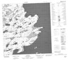
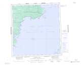
Maps showing Edgar Bay, Mackenzie, Northwest Territories
Edgar Bay is a Bay located in Mackenzie, Northwest Territories.
- Latitude: 61° 52' 1'' North (decimal: 61.8668579)
- Longitude: 114° 37' 5'' West (decimal: -114.6179400)
- Topography Feature Category: Bay
- Geographical Feature: Bay
- Canadian Province/Territory: Northwest Territories
- Location: Mackenzie
- Atlas of Canada Locator Map: Edgar Bay
- GPS Coordinate Locator Map: Edgar Bay Lat/Long
Edgar Bay NTS Map Sheets