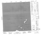
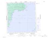
Maps showing Gull Reef, Mackenzie, Northwest Territories
Gull Reef is a Shoal located in Mackenzie, Northwest Territories.
- Latitude: 61° 12' 1'' North (decimal: 61.2001514)
- Longitude: 114° 6' 4'' West (decimal: -114.1012497)
- Topography Feature Category: Shoal
- Geographical Feature: Reef
- Canadian Province/Territory: Northwest Territories
- Location: Mackenzie
- Atlas of Canada Locator Map: Gull Reef
- GPS Coordinate Locator Map: Gull Reef Lat/Long
Gull Reef NTS Map Sheets