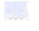
Maps showing Survey Reef, Mackenzie, Northwest Territories
Survey Reef is a Shoal located in Mackenzie, Northwest Territories.
- Latitude: 69° 26' 00'' North (decimal: 69.4333046)
- Longitude: 132° 59' 10'' West (decimal: -132.9860834)
- Topography Feature Category: Shoal
- Geographical Feature: Reef
- Canadian Province/Territory: Northwest Territories
- Location: Mackenzie
- Atlas of Canada Locator Map: Survey Reef
- GPS Coordinate Locator Map: Survey Reef Lat/Long
Survey Reef NTS Map Sheets