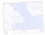
Maps showing Mooshof Point, Nunavut
Mooshof Point is a Cape located in Nunavut.
- Latitude: 68° 28' North (decimal: 68.4666999)
- Longitude: 112° 45' West (decimal: -112.7499999)
- Topography Feature Category: Cape
- Geographical Feature: Point
- Canadian Province/Territory: Nunavut
- Atlas of Canada Locator Map: Mooshof Point
- GPS Coordinate Locator Map: Mooshof Point Lat/Long
Mooshof Point NTS Map Sheets