Compass Bearings
How can I navigate with a compass and a map?
Answer: A compass provides direction through bearings (degrees). However, you must take into account the magnetic declination (found in the right margin of a topographic map) to obtain accurate bearings. The magnetic declination is calculated for the centre of the map and fluctuates annually; the annual change (increasing or decreasing) is shown on the map. For example:
- If the declination in an area is 10° west, add 10° to the setting. If the dial setting was 30°, it should now read 40°.
- If the declination is 10° east, subtract 10° so that the 30° setting will be changed to 20°.
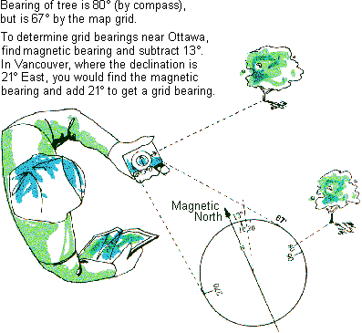
A compass points to magnetic north; but this may not be the same as grid north, which depends on your locality.
If you live close to the imaginary line that runs from Thunder Bay through Savant Lake, in northern Ontario, northwest through Churchill, Manitoba, you're in luck. Here your compass north is approximately the same as grid north. But if you live east of this line, your compass points off to the west, while west of that line it points off to the east. The reason is that the North Magnetic Pole, which attracts the compass needle, is situated at 81.3° N, 110.8° W (2001).
Compasses are available in many forms. The simplest is the common needle compass, which consists of a magnetic needle held free to rotate over a compass card. Remember, when the needle comes to rest, it is pointing at magnetic north. Turn the compass gently under the needle until north on the card lies under the north end of the needle. Magnetic directions are then indicated by the card. (More expensive compasses, such as prismatic and orienteering compasses, have additional features that make it easier to read directions. Instruction booklets for these compasses should be obtained from the dealer.)
Finding compass bearings and grid bearings
To find grid bearings you must know how far off grid north the compass points in your locality. Look in the margin of your NTS topographic map for the compass declination. The rhyme to use is:
Declination East - Magnetic least (i.e. magnetic less than grid)
Declination West - Magnetic best
As an example, in Ottawa the compass points off to the west (declination west) about 13°. So according to the rhyme, a magnetic bearing is greater than a grid bearing.
Following a compass bearing
With your compass oriented (i.e. with North on the card under the north end of the needle), look along the compass bearing you want to follow. Pick a landmark in this direction, such as a large tree or building. Walk toward this landmark, then sight with the compass to the next landmark along the route. Continue to your destination.