Help
The topographic maps found on CanMaps.com were produced by the Centre for Topographic Information of Natural Resources Canada, and are used for a wide variety of applications, from camping, canoeing, fishing and hiking to urban planning, resource development and surveying.
Why? Because they represent the earth's features accurately and to scale, on a two-dimensional surface.
National Topographic System (NTS) map sheets offer detailed information on any particular area. They are an excellent planning tool and guide and, at the same time, help make outdoor adventures enjoyable and safe.
To help you understand what topographic maps are and how to use them, we have answered some of the more commonly asked questions. You will also find tips on how to get the most out of a topographic map, explanations of technical terminology and examples of symbols used to depict common topographical features.
National Topographic System paper maps are available for purchase through our map store. YellowMaps is an official map dealer of Federal Maps Inc., a Regional Distribution Centre and Certified Map Printer for Canada's NTS maps.
The National Topographic System of Canada
Topographic maps produced by Natural Resources Canada conform to the National Topographic System (NTS) of Canada. The National Topographic System provides general-purpose topographic map coverage of the entire Canadian landmass. These maps depict, in detail, ground relief, drainage, forest cover, administrative areas, populated areas, transportation routes and facilities, and cultural features.
They are available in two standard scales, 1/50 000 and 1/250 000. The maps show a geographic grid (longitude and latitude) and a Universal Transverse Mercator (UTM) grid (kilometres). The area covered by a given map sheet is determined by its latitude and longitude. Since the National Topographic System uses a standard numbering system, knowing the map number allows you to quickly identify adjacent map sheets.
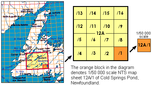
The 1/250 000 scale maps (1 cm equals 2.5 km) are identified by a combination of numbers and letters, from A through P (e.g. 12A, below in yellow). The 1/250 000 blocks are further sub-divided into sixteen segments (1 to 16), forming blocks used for 1/50 000 scale mapping (1 cm equals 0.5 km).
Help Topics
- Map Search
- Locating NTS Map Sheets
- Define Topographic Map
- Map Scale
- Reading Topographical Maps
- Topographic Map Keys
- Compass Bearings
- Map Terminology
- Orienting a Map
- Map Projections: UTM
- Map Datum
- Provisional Prints