Four Brothers Range Topo Map Online
Download Free Topo Map Sheet 104I16 at 1:50,000 scale
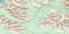
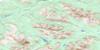
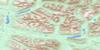
104I16 Four Brothers Range Topo Map
To view this map, mouse over the map preview on the right.
You can also download this topo map for free:
104I16 Four Brothers Range high-resolution topo map image.
Maps for the Four Brothers Range topo map sheet 104I16 at 1:50,000 scale are also available in these versions:
Four Brothers Range Surrounding Area Topo Maps
 |
 |
 |
 |
 |
 |
 |
 |
 |
 |
 |
 |
 |
 |
 |
 |
© Department of Natural Resources Canada. All rights reserved.
Four Brothers Range Gazetteer
The following places can be found on topographic map sheet 104I16 Four Brothers Range:
Four Brothers Range Topo Map: Indian Reserves
Mosquito Creek Indian Reserve 5Réserve indienne Mosquito Creek 5
Four Brothers Range Topo Map: Lakes
Blue Sheep LakeFour Brothers Range Topo Map: Mountains
Cassiar MountainsFour Brothers Range
Kechika Ranges
Stikine Ranges
Four Brothers Range Topo Map: Rivers
Blue Sheep CreekMajor Hart River
Ramhorn Creek
© Department of Natural Resources Canada. All rights reserved.
104I Related Maps:
104I Cry Lake104I01 Tucho River
104I02 Settea Lake
104I03 No Title
104I04 Cake Hill
104I05 Tanzilla Butte
104I06 Snowdrift Creek
104I07 Letain Creek
104I08 Rainbow Lakes
104I09 Cassiar River
104I10 Two Fish Creek
104I11 Hard Lake
104I12 Halfmoon Lake
104I13 Joe Irwin Lake
104I14 Beale Lake
104I15 No Title
104I16 Four Brothers Range
