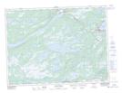
Maps showing Alexander Bay, Newfoundland and Labrador
Alexander Bay is a Unincorporated area located in Newfoundland and Labrador and has an elevation of 126 meters.
- Latitude: 48° 40' 46'' North (decimal: 48.6794444)
- Longitude: 54° 6' 58'' West (decimal: -54.1161111)
- Topography Feature Category: Unincorporated area
- Geographical Feature: Vacated or Seasonal Settlement
- Canadian Province/Territory: Newfoundland and Labrador
- Elevation: 126 meters
- Atlas of Canada Locator Map: Alexander Bay
- GPS Coordinate Locator Map: Alexander Bay Lat/Long
Alexander Bay NTS Map Sheets