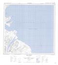
Maps showing Iron Strand, Newfoundland and Labrador
Iron Strand is a Beach located in Newfoundland and Labrador and has an elevation of 17 meters.
- Latitude: 59° 32' 49'' North (decimal: 59.5468736)
- Longitude: 63° 47' 21'' West (decimal: -63.7891967)
- Topography Feature Category: Beach
- Geographical Feature: Strand
- Canadian Province/Territory: Newfoundland and Labrador
- Elevation: 17 meters
- Atlas of Canada Locator Map: Iron Strand
- GPS Coordinate Locator Map: Iron Strand Lat/Long
Iron Strand NTS Map Sheets