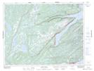
Maps showing King's Point, Baie Verte, Newfoundland and Labrador
King's Point is a Town located in Baie Verte, Newfoundland and Labrador and has an elevation of 23 meters.
- Latitude: 49° 34' 51'' North (decimal: 49.5807861)
- Longitude: 56° 12' 29'' West (decimal: -56.2079999)
- Topography Feature Category: Town
- Geographical Feature: Town
- Canadian Province/Territory: Newfoundland and Labrador
- Elevation: 23 meters
- Location: Baie Verte
- Atlas of Canada Locator Map: King's Point
- GPS Coordinate Locator Map: King's Point Lat/Long
King's Point NTS Map Sheets