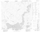
Maps showing Pierrepont Canal, Newfoundland and Labrador
Pierrepont Canal is a Channel located in Newfoundland and Labrador.
- Latitude: 56° 56' 22'' North (decimal: 56.9394880)
- Longitude: 61° 33' 0'' West (decimal: -61.5500802)
- Topography Feature Category: Channel
- Geographical Feature: Canal
- Canadian Province/Territory: Newfoundland and Labrador
- Atlas of Canada Locator Map: Pierrepont Canal
- GPS Coordinate Locator Map: Pierrepont Canal Lat/Long
Pierrepont Canal NTS Map Sheets