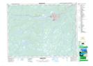
Maps showing Rattling Brook Depot, Newfoundland and Labrador
Rattling Brook Depot is a Unincorporated area located in Newfoundland and Labrador.
- Latitude: 48° 58' 15'' North (decimal: 48.9708333)
- Longitude: 55° 32' 23'' West (decimal: -55.5397222)
- Topography Feature Category: Unincorporated area
- Geographical Feature: Locality
- Canadian Province/Territory: Newfoundland and Labrador
- Atlas of Canada Locator Map: Rattling Brook Depot
- GPS Coordinate Locator Map: Rattling Brook Depot Lat/Long
Rattling Brook Depot NTS Map Sheets