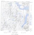
Maps showing Bryant Pass, Torngat Mountains, Newfoundland and Labrador
Bryant Pass is a Valley located in Torngat Mountains, Newfoundland and Labrador.
- Latitude: 59° 35' 1'' North (decimal: 59.5834887)
- Longitude: 64° 0' 57'' West (decimal: -64.0157498)
- Topography Feature Category: Valley
- Geographical Feature: Pass
- Canadian Province/Territory: Newfoundland and Labrador
- Location: Torngat Mountains
- Atlas of Canada Locator Map: Bryant Pass
- GPS Coordinate Locator Map: Bryant Pass Lat/Long
Bryant Pass NTS Map Sheets