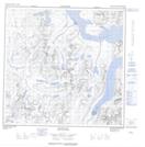
Maps showing Thomas Brown Glacier, Torngat Mountains, Newfoundland and Labrador
Thomas Brown Glacier is a Glacier located in Torngat Mountains, Newfoundland and Labrador.
- Latitude: 59° 35' 21'' North (decimal: 59.5891666)
- Longitude: 64° 9' 42'' West (decimal: -64.1616666)
- Topography Feature Category: Glacier
- Geographical Feature: Glacier
- Canadian Province/Territory: Newfoundland and Labrador
- Location: Torngat Mountains
- Atlas of Canada Locator Map: Thomas Brown Glacier
- GPS Coordinate Locator Map: Thomas Brown Glacier Lat/Long
Thomas Brown Glacier NTS Map Sheets