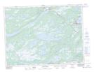
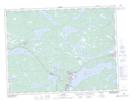
Maps showing Strouds Bog, Terra Nova, Newfoundland and Labrador
Strouds Bog is a Low vegetation located in Terra Nova, Newfoundland and Labrador.
- Latitude: 48° 44' 8'' North (decimal: 48.7355555)
- Longitude: 54° 7' 47'' West (decimal: -54.1297222)
- Topography Feature Category: Low vegetation
- Geographical Feature: Bog
- Canadian Province/Territory: Newfoundland and Labrador
- Location: Terra Nova
- Atlas of Canada Locator Map: Strouds Bog
- GPS Coordinate Locator Map: Strouds Bog Lat/Long
Strouds Bog NTS Map Sheets