Maps showing Bay of Fundy, Annapolis, Nova Scotia
Bay of Fundy is a Bay located in Annapolis, Nova Scotia and has an elevation of 0 meters.
- Latitude: 45° 0' North (decimal: 45)
- Longitude: 65° 30' West (decimal: -65.5)
- Topography Feature Category: Bay
- Geographical Feature: Bay
- Canadian Province/Territory: Nova Scotia
- Elevation: 0 meters
- Location: Annapolis
- Atlas of Canada Locator Map: Bay of Fundy
- GPS Coordinate Locator Map: Bay of Fundy Lat/Long
Bay of Fundy NTS Map Sheets
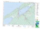
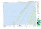
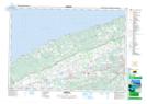
021A12 Digby Topographic Map at 1:50,000 scale
021A13 Granville Ferry Topographic Map at 1:50,000 scale
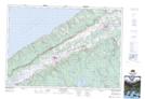
021A14 Bridgetown Topographic Map at 1:50,000 scale
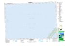
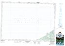
021B01 Meteghan Topographic Map at 1:50,000 scale
021B08 Church Point Topographic Map at 1:50,000 scale
021B09 Centreville Topographic Map at 1:50,000 scale
021B10 Grand Manan Island Topographic Map at 1:50,000 scale
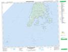
021B15 Campobello Island Topographic Map at 1:50,000 scale
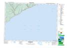
021G02 St George Topographic Map at 1:50,000 scale
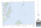
021H02 Berwick Topographic Map at 1:50,000 scale
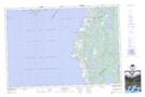
021H03 Margaretsville Topographic Map at 1:50,000 scale
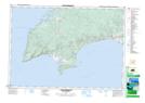
021H06 Salmon River Topographic Map at 1:50,000 scale
021H07 Cape Chignecto Topographic Map at 1:50,000 scale
021A Annapolis Royal Topographic Map at 1:250,000 scale
021B Eastport Topographic Map at 1:250,000 scale
021G Fredericton Topographic Map at 1:250,000 scale
021H Amherst Topographic Map at 1:250,000 scale