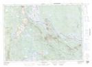
Maps showing The Ledges, York, New Brunswick
The Ledges is a Mountain located in York, New Brunswick and has an elevation of 159 meters.
- Latitude: 45° 39' 5'' North (decimal: 45.6515224)
- Longitude: 67° 33' 12'' West (decimal: -67.5534440)
- Topography Feature Category: Mountain
- Geographical Feature: Hill
- Canadian Province/Territory: New Brunswick
- Elevation: 159 meters
- Location: York
- Atlas of Canada Locator Map: The Ledges
- GPS Coordinate Locator Map: The Ledges Lat/Long
The Ledges NTS Map Sheets