Maps showing Îlet Bittern, Rivière-Koksoak; Kativik, Quebec
Îlet Bittern is a Island located in Rivière-Koksoak; Kativik, Quebec and has an elevation of 0 meters.
- Latitude: 58° 47' 9'' North (decimal: 58.7857434)
- Longitude: 69° 49' 19'' West (decimal: -69.8220671)
- Topography Feature Category: Island
- Geographical Feature: Îlot / Ilot
- Canadian Province/Territory: Quebec
- Elevation: 0 meters
- Location: Rivière-Koksoak; Kativik
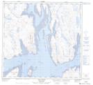
- Atlas of Canada Locator Map: Îlet Bittern
- GPS Coordinate Locator Map: Îlet Bittern Lat/Long
Îlet Bittern NTS Map Sheets