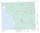
Maps showing Pointe Poplar, Waskaganish; Jamésie, Quebec
Pointe Poplar is a Cape located in Waskaganish; Jamésie, Quebec.
- Latitude: 51° 30' 47'' North (decimal: 51.5130556)
- Longitude: 78° 49' 31'' West (decimal: -78.8252778)
- Topography Feature Category: Cape
- Geographical Feature: Pointe
- Canadian Province/Territory: Quebec
- Location: Waskaganish; Jamésie
- GPS Coordinate Locator Map: Pointe Poplar Lat/Long
Pointe Poplar NTS Map Sheets