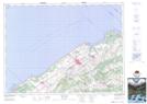
Maps showing Sainte-Jeanne-d'Arc, Sainte-Jeanne-d'Arc; La Mitis, Quebec
Sainte-Jeanne-d'Arc is a Village located in Sainte-Jeanne-d'Arc; La Mitis, Quebec and has an elevation of 247 meters.
- Latitude: 48° 30' North (decimal: 48.4999999)
- Longitude: 67° 57' West (decimal: -67.9500000)
- Topography Feature Category: Village
- Geographical Feature: Municipalité de paroisse
- Canadian Province/Territory: Quebec
- Elevation: 247 meters
- Location: Sainte-Jeanne-d'Arc; La Mitis
- Atlas of Canada Locator Map: Sainte-Jeanne-d'Arc
- GPS Coordinate Locator Map: Sainte-Jeanne-d'Arc Lat/Long
Sainte-Jeanne-d'Arc NTS Map Sheets